photos for this can be seen be clicking on this link-
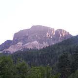 |
| The Pyramid (day one) |
Seven or eight years ago I had climbed Pagosa Peak with my friends Ian and Duane. On that distant summer day we could see a far off summit to the northwest, standing above all the others. Looking at the map and doing some slight triangulation I guessed it to be the Rio Grande Pyramid. It did not take long for us to decide we were going to climb it next year, but next year just kept getting put off until it was more of a joke or a fantasy that would never really happen. It was far in the backcountry and we were here living lives that did not leave a lot of time for big trips. I am not sure what, but something happened this year and one day we were talking about doing it in our joking way that it had now become, and somehow I was planning the hike in all seriousness.
This was to be our first real hike crossing the Weminuche Wilderness, leaving one morning, do a trek and a climb, then be picked up the next afternoon on the other side of the mountains. So that was how we found ourselves at six-thirty in the morning in late August, standing at the Poison Park Trailhead, rubbing eyes to remove the last vestiges of sleep. We shuffle around a bit, eating some homemade sourdough English muffins, and shoulder on the packs. These are fairly light, consisting of little more than food, change of clothing, sleeping bags, and a tarp. I have my water filtration system, so between us we carry less than a gallon of water. Surprisingly I am the only one who brought a hiking stick. Usually both Duane and Ian carry a wooden practice sword that doubles nicely as a stick. But not this time. They were going in light.
The first seven or eight minutes on the trail are flat and easy.Then we drop. A lot. Dropping down switchbacks for about half an hour brings us out at the top of the Weminuche Valley. A large and beautiful valley that is mostly private, it is made up of a few ranches that cater to tourists and hunters. We follow a fence line and soon come to a corner post. On the post is a trail sign showing Fall Creek Trail stretching away , following the fence west beyond sight, and telling us that we are on Weminuche Trail.
From here we hike about ten minutes through forest until we enter Ioca Park, a quarter-mile long meadow skirted by old stubby looking aspen forest.Back into the firs again and we soon come upon our first creek crossing that is wider than something that you can step over. This is Milk Creek, which after crossing we find some nice logs to sit on and take our first break after going just under three miles.
Close to a mile later we step into Elk Park, an area of dense foliage rising no more than three or four foot and having a bit of a marshy feel about it. After this we begin climbing more, although most of it is still pretty easy. We are soon overtaken by a couple traveling on horseback. They say that they left from Thirtymile Trailhead(where we plan on ending our trip) the day before , coming down Squaw Creek Trail east of us and now taking the trail we are using to return. Before they are too far ahead the woman turns to us and asks what the pheasant looking things are. Without much hesitation both Duane and I answer, "Blue Grouse". They then press on and before they are out of sight I realize that they have no camping gear between them, blankets, tents ,or anything. Strange.
Three miles past Milk Creek we come to the next major watercourse. This is the East Fork of the Weminuche Creek, and before we cross it we stop at a nice camp site to take a longer break. Removing our packs for the first time we eat some fruit and chat. We also decide to drink all of our water so that we can refill here, not having to make another big stop for awhile. While we sit we watch two hikers come down the trail and cross the creek, eventually coming over to us to talk. They were just returning from Ute Lake, a pretty far hike in and south west of our eventual destination.
After they take their leave we refill our bottles and set off ourselves. Across the creek the trail splits, ours laid straight before us, with the other heading northeast, following toward the source of the creek, although the signpost is little more than a rotting hunk of wood, with no indication of which trail goes where.
After about three-quarters of a mile of easy terrain we reach the next split in the trail. Here is an actual sign that can be read and base a decision upon. The lower trail takes you to Divide Lakes, the upper towards Granite Lake. We stop to think for a moment. We are wanting to climb Granite Peak on the way, we just do not know which trail would best do it for us. The Peak lays in between the two trails. We soon decide to stay on the trail towards Granite Lake, as it is the one we are supposed to be on anyhow. We would just look for a likely spot to climb it from. So off we go. It quickly becomes a steep climb. Eventually we see Granite Peak not too far off behind a small rise to the west of us. It is covered with a good mix of exposed granite slabs and dense fir. It is also shorter than any mountain around it. Coming in at 10,670 feet it is far shy of timberline yet still looks like a fun climb.
So we hop off the trail to climb this rise and see our options. It takes awhile of going to various spots on the ridge to get a good view but nothing seems to work well. We decide to get back on the trail and look for a better spot. It does not take us much longer to find a side trail taking off toward the peak. We follow it a ways to find it only going to a nice camp sight. But, from here we can also see that it is not going to be easy. There is a very deep canyon between us and the mountain, making it look like quite a journey of its own.
Now, those who know me are aware that passing by a peak and not climbing it is very difficult for me, especially when I was already planning on it. But somehow in the first couple of miles this morning I had moved my knee wrong, or I possibly should have spent some time stretching it before we started, or something. Anyhow, what started as a bit of a twinge was now becoming excruciating. I was able to walk in a semblance of normal hiking, so the others had not noticed yet, but going uphill was intense, and the little bits of downhill we had done was worse. So while we were weighing the pro's and con's of climbing the peak, I think I surprised both Duane and Ian by not pushing to go up. It is soon decided that it would take more time than we were willing to put into it today.
We turn back and now make our way to the main trail again. Once there it is more climbing, but now the hill on our left side is made up of huge chunks of granite, making for a nice change in the scenery. When we reach the top of this long climb we take a nice little break, removing the packs and lounging against some rocks. We are now at 10,600 and it is truly beginning to feel like high country. I pull out the map and see that the trail passes well above Granite Lake, but we all hope for at least a glimpse of it.
Setting off again, we find the trail is now much flatter, enabling us to move a little quicker. We are suddenly stopped short, with the lake coming into view. This is easily one of the most beautiful lakes that I have ever seen. It is surrounded by boulders and large slabs of granite, cliffs trimmed with fir trees, and mountains rising above on all sides. As we move along we are treated to little glimpses of the lake, still much lower down than us. Abruptly we come to a switchback. This was not on the map when we last checked out the trail, but it is not the most detailed map so we go along with it. We head down the path, doubling back in the direction we came and after a couple more switchbacks we realize that we are dropping down to the lake. There were so many little side trails in the mile before this that we could have missed the main one, but we figure that we can always climb back up later. We can also see that the couple on horseback came this way as well, making me feel not quite so bad for missing the true path.
A few minutes later we reach the shore. This is well worth coming down for. After taking some photos we begin following the shoreline towards the northern end of the lake. There is a large granite wall there we want to check out, and upon reaching it Duane and Ian jump up onto a large boulder sticking out from lake's edge, asking me to take a photo of them while they pose.
Now it is time to find our way out of this bowl. After a bit we find a small trail heading up in the direction we want to go. It quickly turns into a very steep climb, and after a few short breaks in between pushing up, we are out. The trail takes a sharp turn to the east and then it just disappears. After a short conference we decide to make our way northeast until we hit the Weminuche Trail again. It does not take us long to regain it and we are again moving almost directly north.
We now pass through a short marshy area into a fir forest, which opens onto something that makes me stop in my tracks. It quickly becomes one of the big highlights of the hike for me. Our way goes through a pass where on one side is a steep mountain dropping to the trail, the other it is almost as steep but much shorter in height; the awe inspiring part is the way that they look. On the east the taller slope is covered in a scree of large sharp stones that I am used to seeing and climbing in the mountains southeast of here, to the west the lesser slope is made of the large granite slabs and reddish colored dirt that are more the norm for here. We slowly walk through this area of sharp contrast in an almost daze, seeing the competing contrasts meeting right at our feet. As a bit of an added bonus, as we step out of this area and look down, I am greeted by a small handful of bilberries, something that seems in short supply this year.
After munching a couple of berries each we move on. The trail begins to drop and we hike through a series of forests and meadows in which we lose about 700 feet in a mile and a half. We come out into the Los PinosRiver Valley which we will now stay in or skirt the edges of until we find a place to camp later. Entering the valley we easily cross Snowslide Creek and move on. But a few minutes later we come to the Pinos itself. While nowhere near as large as it gets when it approaches the town of Bayfield much lower down, it still presents the first bit of water that we have to get wet to cross. We slip off our shoes and socks and present our poor tender feet to a rocky bed of water that comes to the thighs. I cannot help but laugh knowing that I am the only one with a staff to help in the fording. I think that I would probably lose my footing without it, but Ian crosses it with little difficulty and the two of us are soon across before Duane enters. Watching him trying to find firm footing I take pity and toss him my beloved stick, bringing him to our side of the river in short order.
Not much further from here we reach a small cluster of trails. Our's merges with the Pine Rim Trail, which we will be following, and the Rincon la Osa Trail heading off to the west, which is the way the hikers we met this morning had come from. And we are now ready for a good break to eat some food. By this point we have gone about twelve miles and it feels like time to chill out. So we move off into the forest that follows the river valley where we see a large camp site. It actually turns out to be an outfitters camp, with ropes, saws and logs strewn all about, the whole camp being near fifty yards across. We eat and wander about looking at some of the various structures for about fifteen minutes before deciding to move on.
By this time my knee is seriously hurting, and I know I am going to start slowing us down, so I figure that this would be a good time to tell them what is going on with it. After discussing the hinge of my leg for a minute or two we take off, with my knee feeling stiff from a long rest, hoping that these last couple miles go easy on me.
Now the trail follows along the edge of the river valley, going in and out of forests, up and down small hills, but over all pretty flat and uneventful. Truth to tell I am zoning out right now and I am not taking in everything around me as I usually do. Just keep moving, get to a place where I can languish for many restful hours. After close to two miles of this we approach another trail splitting and we cluster up around the signpost. This marks where the Rincon la Vaca Trail begins, heading west towards the Pyramid. We look around and see a tall pyramid shaped mountain not too far off, we should be able to do that pretty easy in the morning. We also see some inviting trees only a quarter mile off from us that should do nice for camping. We set off toward them, following this new trail and I am quickly outpaced by the others. I have to stop. My knee is hurting so much that I cannot even bend it now; supporting weight with it is not working well either. I move along slowly, taking about twenty minutes to cross the meadow. But in that time my companions had found an easy to reach camp site and were already collecting firewood. All I had to do was get there and sit down on a stump.
Once they had a nice fire blazing I set up my tarp as a tent and we stow our gear underneath. Now I am not much of one for modern medicine, but Duane says my knee looks very swollen so I gratefully accept some Ibuprofen from Ian. I also take some time to soak my leg in a nearby stream. By the time we are ready to just sit around the fire and relax it is feeling much better. It drizzles off and on, but it never really rains until we are ready lay down for the night. It comes down harder then but even that does not last long. We make ourselves comfortable and one by one we drift off.
to be continued...