Pages

Sunday, December 27, 2009

A Year in Peaks

The Year: 2009
The Goal: Thirty peaks

One of my major passions is hiking. Especially hiking that brings me to the slopes of an even deeper passion, mountain peaks, specifically me climbing up them and being on them. This year I made what I thought was a modest goal of thirty peaks. (I say modest, but I make this a goal almost every year, yet never reach it). Now with the year coming to a close I can look back and see...
I failed not even half way there. That is not to say that I did not have fun trying! So now I will give a short run down or what was acomplished. I must mention that some of them are not named on maps, so those are named by wht I have heard from others, or more usual, names I give them that reflect where they are in relation to other peaks or such.

Day 1 Mid-June
Peaks- Blackhead (12,500 ft.), Nipple (12,060 ft.), Chair (12,220 ft.), Quartz 1 (12,376 ft.), Sand (12,410 ft.), Quartz 2 (12,320 ft.), Quartz 3 (12,390 ft.)
I am in the process of writing this hike out as its own blog to be posted in the next month or two. A quick rundown. Started hiking before dawn and reached Blackhead at sunrise. Backtracked to the gap and then scaled Nipple. Headed toward Chair Mountain from a direction that I have never been from. After that I briefly got on the Rito Blanco Trail that takes you to Quartz Lake. Leaving the trail I headed up Quartz 1, and from there it is pretty easy to follow the ridge line from one peak to the next. A beautiful and fulfilling early season hike if there ever was one.

Day 2 Late August
Peak- Rio Grande Pyramid (13,821 ft.)
A long hike deep into the Weminuche Wilderness to the tallest mountain in the area.
To read about this hike check these links:

Day 3 Late September
Peak- Pagosa Peak (12,640 ft.)
Another one that I am working on to post later. This was just me and my 8 year old daughter, Thalia climbing a classic peak.

So that adds up to only 9 peaks. A sad number, but every hike was so memorable that they have more than made up for the lack. I think for 2010 I will try for a more modest goal of 25 peaks.
Wish me luck!

Saturday, December 19, 2009

Birthday for Thaddeus


Six years and two days ago Return of the King was released in the United States. It was to be a climatic moment for me. The culmination of anticipation that lasted about five years was about to be achieved. (Well, not quite. The extended edition was still eleven months away). But the feeling was not what I was expecting. We were due to have our second child the day before and he still wasn't here. I had bought the tickets a week earlier but we did not truly expect to use them. So now that the time had come it was with a slightly different emotion. Still excited but with reservations. But we needed to be in Durango anyhow for the birth so it couldn't hurt to be there for the movie as well. It was almost surreal to be sitting there watching these huge epic battles while every so often Dawn lets me know to time a contraction. Needless to say neither one of us put our full attention into the film. After it is over and we step outside into the cold and frosty air, we discuss our options. Dawn thought she was in labor but that it was false as it had seemed to subside. At the same time we did not want to go home (an hour and a half away,) only to turn back. Once it had been talked about for a while we decided to head over to the hospital just to check if she was indeed in labor. A good thing we did to. After checking they quickly put her in a room and got the midwife on call. And not two hours after the movie was over we were holding our first baby boy. The time was just four minutes past midnight, the date had just changed to the 18Th of December.

Flash foward to yesterday. I had spent a few minutes the night before giving a brief homage to Tolkien and Peter Jackson by looking over the books and movies in my collection. And now on Thad's birthday I must work. (Those slave drivers over at Kips!!!) (just kidding). While there Jordan, a coworker, gives me an old first edition of The Silmarillion, one of my favorite Tolkien books , to add to my collection! Meanwhile back at home Dawn has spent the day working on a Sprouted Spelt Sour Cream Chocolate Cake.


I arrived home and by 4:30 we were ready for his party. Poor little guy spent the previous half hour bummed out that it wasn't time yet. But it did not take to long before it was time to snuff those candles, which he tackled with one mighty blow:
The cake was delicious and before long Thad was opening gifts.


After the presents were opened and he graciously gave out thank you's, everyone left and our home was back to a semblance of normality. Toys were played, dinner was made and ate, to be followed by bedtime, ending a day of fun for a little boy.

Wednesday, December 2, 2009

the Pyramid (day two)

Click on this link to view photos

the Pyramid (day two)

I awake after an uneventful night’s rest and start the fire again. My leg is feeling a bit better so I start stretching, but that only brings the pain back again. When the fire is going well I wake Ian and Duane, and once we have eaten, and they have had their coffee we break camp. We take our time, slightly sore from the previous day, and knowing that it should not take long to reach the Rio Grande Pyramid. After finishing the packing we decide to leave the packs here, just taking food for lunch and some water, as we will be returning to this spot after the mountain on our way back to the main trail.

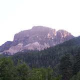
We cross the Rincon la Vaca and begin to climb the ridge before us to the north. Our plan is to top the ridge, (which also happens to be the Continental Divide,) and follow the ridge west to the Pyramid, taking a high point or two along the way. Getting to the top of the ridge is like a wake up call to the body; we ascend about one thousand feet in less than half a mile. There is some confusion about the climb as we are not certain of where the Pyramid is in relation to us. The higher we go the more certain we are that the point we saw yesterday is not it. When we finally get on top of the ridge we have a view of the whole valley and the mountains surrounding it and there it is. It is a lot further off than we thought and we now realize that we should have left much earlier if we are to climb it and get picked up on time. It is quickly decided that we will not follow the ridgeline, we will instead take a trail that we crossed that skirts the south side of the ridge and drops us at the base of the Pyramid.

Off we go again following a path that frequently disappears from a large amount of deadfall on it. It seems extraordinarily dry here, some of the fallen trees have obviously toppled in just the last week or two and the soil around the root systems looks and feels bone dry. It takes us quite a while to get through this section, clambering over and around trees, but we eventually make it through and we now have open trail before us with stunning views that keep us moving slowly at first. There is a striking formation on the south arm of the Pyramid aptly named The Window that it is hard to take my eyes from. A huge square of stone is just missing from this massive rock wall, giving it the appearance of a large window without the top lintel.

The trail now takes us on the bottom edge of some large scree-covered slopes where the rocks are all small and gravel sized, another thing that I am not used to seeing on the side of a mountain. We top a slight rise and there below us is a small pond in a valley covered with Mountain Snowberry, a high country brush that rarely gets more than waist high at this altitude. As we drop down into this we see the trail cutting right through the brush and it looks to be overgrowing the path in most places. I walk through with my staff before me, using it to knock water from last nights rain off the overhanging branches, but within a matter of minutes my shorts are soaked. The others behind get to reap the benefits of my getting wet so I find myself consoled. Slightly. After pushing our way through about half of the valley, clouds begin to move in around us, shrouding most of the mountains and letting a thin drizzle fall on us.

Once we are out of the valley we find a clear spot and discuss our options. Should we continue on and hope the rain fades? Or should we turn back now and save ourselves a soaking? There are no sheltering trees on the trail before us now as we have been hovering just under timberline for a while now. We decide to press on. Ahead of us we can see a trail taking off of ours that cuts down into the La Vacca valley just a little before the climbing of the mountain, so we can always use that to escape the weather if need be.

The next part of the trail follows the upper edge of a large bowl shaped valley. So we start trekking around it making a considerable half circle. Now a short climb and we are at the split of the trail, with the northern route taking us to the summit, the southern being our way out of the storm. It still has not done more than sprinkle on us so we push on in the anticipation that it will not worsen. The path here leads us up steeply on a slope covered with large flat stones that takes about five minutes to traverse. We top out on this huge rocky saddle in between the pyramid and what we thought was the Pyramid before. With the clouds rolling over and around us looking like fog and the way the terrain here looks it feels as if we are in what I imagine the Scottish Highlands to be like. It has a very surreal feel to it opening me to a deep longing, for what I do not know.

Now I do not have an altimeter as my GPS fritzed this summer, but looking at the map I would say that standing here in this saddle we are at the same altitude as the top of Pagosa Peak. Which means we only have around twelve or thirteen hundred feet to climb. As I relay this information to Ian the clouds begin to break around the mountain and we are given our first up close view. We can see the trail going up and it looks rough. My leg has gotten quite painful and I am now not so sure about the wisdom of doing this and getting back down without major problems for everyone. I say as much to my comrades and give my camera to Ian so there will be photos from the top even if I don’t make it. And off we go again. This flat saddle stretches for about a quarter mile before the mountain abruptly rises out of it.

Before we begin scaling we take a short break to look up the near vertical rise. It is now that I realize that I have been carrying Duane’s water and staying behind me most of the way he had not had a single drink since leaving camp this morning. He gratefully takes the proffered bottle and we begin our ascent. The first part is a pretty easy scramble up a rocky slope with a small shelf at the top. Then it truly begins. We can see the trail going up through the gravelly rocks and we start up it. We quickly realize that we should get off on the side of the trail where the rocks are larger and you don’t slide back a step for every two taken. Now the only danger is just not shifting any of these large rocks to drop on whoever is below. It takes us quite awhile to climb this slope, but looking up it seems as if there is a short flatter spot with the final climb looking much easier, relatively speaking. I reach the top of this ahead of the others and I am hit with a bit of a shock. What we thought was the final bit of the mountain for us to tackle and that I am now standing near is nothing more that a rather large piling. Large enough that it had blocked out the real mountain that is still a quarter mile off across a flat boulder- strewn field that I am standing on the edge of. And getting up the Peak makes what we just did look like child’s play. Those words of encouragement that I was about to call out die on my lips. My knee is twinging at me as if trying to tell me to stop now while I can turn back easily.

Duane and Ian soon join me and I see the expressions of numbed disbelief that must mirror my own. We slowly move across the field that in any other circumstance would leave me awestruck with its stark beauty. This is not to say it was not enjoyed. The views from here are epic, places I have never seen before and might never again. But my thoughts are mostly on what I should do with my knee being as it is. It feels almost like it did before we stopped yesterday, if I am able to get up this there is not much to say that I will get down again, at least not without help.

While in the midst of these gloomy thoughts I realize that I should take this opportunity to call Christine, who is to pick us up this afternoon. I had guessed that we would be out by three or so, but now I am thinking more like five or six-o-clock. I give her a call and everything works out just fine, she herself cannot make it till five, letting all of us feel less pressured. Deeming things to be a bit better now I decide to press on to the top. Coming closer this last part, steep as it may be, does not look any harder than other climbs I have done, but with the present circumstances it seems more daunting . We start climbing up through the rocks , both large and small that give this mountain its shape, with only a few spots that actually feel dangerous, and nothing very technical, so the only thing that stops us is the breath we need to catch every so often. Slopes like this made up of just rock are actually easier to climb than their packed dirt or grassy brethren, it is not just a steady rise unchanging, but every step is carefully chosen so as not to shift rock.

Finally I make it to the top, 13,821 feet, only a few steps ahead of the others, giving me a moment to take in a totally unobstructed view by myself. Wow. The panorama is spectacular as the clouds have risen high enough to unshroud almost every peak around, near and far. There is a lot that I can make out from here. V-Rock, at the very end of the Chalks Range in the South San Juan Wilderness, is just barely visible. Slightly more discernable is Square Top and parts of Quartz Ridge. There are more but I am not yet ready to study the view in this direction now. I turn to look the other direction and am overwhelmed by the beauty. I am looking at mountains now that I have never before gazed upon. It sinks in as I stare out across this expanse that all the climbs and hikes I have done in the past sixteen years have barely scratched the San Juans. I have never really ventured out of my backyard and crossed the fence so to speak. Long minutes seem to pass mesmerized for me in the few seconds it takes Ian to summit who is quickly followed by Duane. In this brief time I have had one of those moments where everything shifts inside and I am grateful to be given this time here.

Turning back towards my friends we pass out congratulations to each other. It is now that I feel the cold. There is a stiff breeze blowing with occasional stronger gusts and the sun that could warm us is only showing itself to a far off valley. We huddle down near the rock cairn marking the highest point but it offers no shelter from the wind. After removing my pack I look over to the cairn in hopes of finding the ledger and I am pleasantly surprised. Some of the peaks I have been on have a glass jar with some loose papers in which to write your name and date when you climbed. Most have nothing at all, just a small pile of rocks letting you know this is the summit. Here though is a heavy duty three inch PVC pipe with caps screwed on both ends that is chained to rock somewhere under this cairn on which it lays. I have heard tell of these before but have never encountered any in the mountains around Pagosa. I open it to see it filled with papers. I take one out and try to write legibly with fingers that are quickly numbing. Passing it on to Duane I read a couple entries but soon return them. It is too cold for hanging out reading names and inspirational thoughts right now. We take a few more minutes to eat lunch and then we share out the little bit of mead left over from last night. Up here these few sips we are allowed seem to be magnified in flavor. I spend another minute pointing out mountains we know and then I see it. Pagosa Peak is there, where it all started for us, all those long years ago, from this distance looking almost like the other mountains near it, but I can make out a few telltale landmarks near it.

It does not take long before the chill reminds us to get a move on. I have no idea how my knee is going to be for getting down so I set off while the others take in their last minutes up here. After eating Ian gave me some more Ibuprophin, so it is feeling somewhat better, but all the same I am glad again for my staff, which becomes like a third leg for this descent. Descending through the rocks goes quickly, although we must be more careful as it is easier to step on a rock wrong making it shift dangerously underfoot. After crossing the boulder field below this we come to the steep gravely slope. We look over the edge and then plunge down. We slide on our shoes almost like skiing and while we are down in a matter of seconds we all have to stop at the bottom to empty our shoes of dirt and small rocks. Hurt knee or no, we are down in less than half the time it took to climb.

We are soon back to where the trail divided this morning and we choose to drop down into the valley, covering all new terrain, rather than backtrack the Skyline Trail. We follow the path through a rock field that opens up onto a long green meadow where the trail begins to fade. If we had the time to go the Window we could easily find it and head that direction, but from above I had seen the trail we wanted that comes off of this one near the end of the field so we are able to head straight for it. We find the trail on the south eastern end of the meadow dropping down into a forest. It twists and winds through fir trees and the brushy Mountain Snowberry, taking us lower with each step. After close to a half mile of this we come to a deeply cut rocky gully with a small stream flowing through it that we must now cross. Once beyond this our route becomes more exposed, the terrain is now a mineralized packed dirt streaked with varying colors and a scattering of rocks that follows on the eastern side of the creek through a series of small waterfalls. We are now on the part of the trail that we could see this morning, tempting us during the steady drizzle. I take a moment to stop in my thankfulness that we decided to push on and climb the Pyramid, looking back at all we have traversed. I realize now that I have found another area that I will always love and cherish, and I hope that someday I can return with my family and do some real exploring.

I begin moving again, shaking off the daze of daydreaming and soon, about a quarter mile from crossing the stream, we are plunged into a dense fir forest where the path feels as if it meanders, slowly bringing us to the valley floor below. Twenty minutes of this leaves us about thirty feet above that floor that opens up below us into a huge meadow. Pausing for a moment to take it in, we see a couple of backpackers slowly heading our way. We follow the trail down into the meadow and eagerly make our way towards the hikers, looking forward to talking to them and hoping they can give us a good estimate on getting to the trailhead. They turn out to be a man and a woman, both seeming at ease in the wilderness and sporting some expensive and high tech gear. We chat and once they hear the route we took to climb the Pyramid we are met with mild shock. We are then told how much easier it is to take the valley and head for the Window, from there heading up the southern arm to summit, which he has already done twice. There is even more surprise when it is learned we plan on being out by five. The trail out is longer than we think, and we are told we had better hustle to make it out before dark. After some hasty goodbyes we take the advice and hustle.

It takes us another half hour to reach our camp, refill water bottles and put on packs that don’t feel as comfortable as before. Since reaching the meadow my knee was numbing, making it easier to move faster, but after stopping here it begins to flare again. We cut off the trail to gain some time heading back into the Los Pinos River Valley and quickly we are back on the Pine Rim Trail. A mile later we are at Weminuche Pass, standing on the Continental Divide once more. Everything on one side dropping into the Los Pinos, while on the other it all drops into Weminuche Creek, (not the same that we crossed yesterday,) which in turn drops into the Rio Grande Reservoir, about three and a half miles ahead of us. Somewhere around here is the start of Skyline Trail, which we used to get near the Pyramid this morning, but with the sign having been removed years before we don’t see it. The trail we are on, while still the same, now switches its name to Weminuche Trail and taking it we step into the Rio Grande National Forest, leaving behind my much loved San Juan.

We now wind our way through meadows and forests, of both fir and aspen, as we slowly lose altitude. I am in the lead and setting the pace, having found a pretty good shuffle that keeps my knee from hurting much and moves us faster than our average hiking speed. We only meet two more people, an older couple, about halfway between the Divide and the Reservoir. I try to make some noise as I approach them, but I still make the woman jump when she sees me from just a few feet away. Not wanting to lose my shuffle, I slow only long enough to apologize for the fright and wish them well on their journey.

After we have gone about two and a half miles from the Divide the trail drops steeply on loose gravel. It drops us back down to Weminuche Creek where we come to a bridge that spans it. On the other side is a slick of water coming down a slope that is covered with green. Moss and small plants abound and I have to stop to photograph the bridge with this brilliant display behind it.

From here the trail continues to drop more quickly and it is not long before we can catch glimpses of the Reservoir through the trees, though it is still a way off. Seeing this is very heartening. I don’t know about the others, but I am feeling pretty worn. This pace and the way I am moving seem to be wearing me down quicker than usual. We soon find ourselves a couple hundred yards above the Reservoir and the trail turns sharply to the east to follow along it. We only have to go along the lake for the final third of its length, which looks to be about a mile. So we continue on, dropping ever lower. Soon we see a road on the other side of the lake with the occasional car or truck moving along it. It is almost surreal to see this sign of civilization and still be hiking. Short of hiking around Wolf Creek, I have never had an encounter like it.

As we approach the dam I can see the caretaker’s house on the other side and I begin to wonder just where exactly the trailhead is. We drop to within twenty yards of the lake and I decide to consult the map. A closer look than any previous one shows it to be a further half mile. I look behind me. I cannot see either of my companions and I don’t think I should stand for long or it will be hard to take off again with my knee. I quickly scrawl a large arrow in the dirt showing which way I am going and push on.

The trail climbs up a short but steep hill, then levels off, and shortly it is dropping slowly again. I pass two more hikers who are out for an afternoon jaunt and soon I can see a campground through the trees. My step begins to hurry more and before long some log cabins pop into view, and then there it is, the trailhead. And not too much further is Christine standing next to her car. I look to see that it is six-fifteen, when from behind the car Asia, my boss’s dog comes out, moving slowly closer and barking low. A moment later Asia recognizes me and is bounding all around, wanting me to notice her.

Christine, my boss Joe’s fiancĂ©e, pulls out some bottles of cold juice that she brought for us. I drop my pack unceremoniously and take the proffered bottle gratefully, dropping myself to the ground as well. About two minutes later Ian comes out of the trees and Asia goes crazy thinking it is Joe. Disappointed, but still happy for more attention, she runs around waiting for someone who is not going to come. She is all wound up again when Duane appears five minutes later. He joins us to sit on the grass as we reflect on an epic weekend.

Minutes later we stagger to our feet and stow our gear in the back of the car, then load ourselves in. It is about a half hour drive to Creede from here and Christine points out mountains, tells us about various areas, and gives us a recent history of the ranches we pass. Upon reaching Creede we are given a short drive through tour of the little town before we are back on the road, heading to South Fork, where a vehicle awaits us that we can take to Pagosa. We find the car we are to borrow and transfer our things, saying goodbye to Christine. We watch the sky darken into twilight as we drive over Wolf Creek Pass, and just a few hours after reaching the trailhead we make our weary way into Pagosa springs, our hometown. Stopping at Kip’s Grill we close our weekend with a much appreciated beer and a sense of comradeship stronger than when we began.

Tuesday, October 13, 2009

The Pyramid (day one)

photos for this can be seen be clicking on this link-
The Pyramid (day one)
Seven or eight years ago I had climbed Pagosa Peak with my friends Ian and Duane. On that distant summer day we could see a far off summit to the northwest, standing above all the others. Looking at the map and doing some slight triangulation I guessed it to be the Rio Grande Pyramid. It did not take long for us to decide we were going to climb it next year, but next year just kept getting put off until it was more of a joke or a fantasy that would never really happen. It was far in the backcountry and we were here living lives that did not leave a lot of time for big trips. I am not sure what, but something happened this year and one day we were talking about doing it in our joking way that it had now become, and somehow I was planning the hike in all seriousness.

This was to be our first real hike crossing the Weminuche Wilderness, leaving one morning, do a trek and a climb, then be picked up the next afternoon on the other side of the mountains. So that was how we found ourselves at six-thirty in the morning in late August, standing at the Poison Park Trailhead, rubbing eyes to remove the last vestiges of sleep. We shuffle around a bit, eating some homemade sourdough English muffins, and shoulder on the packs. These are fairly light, consisting of little more than food, change of clothing, sleeping bags, and a tarp. I have my water filtration system, so between us we carry less than a gallon of water. Surprisingly I am the only one who brought a hiking stick. Usually both Duane and Ian carry a wooden practice sword that doubles nicely as a stick. But not this time. They were going in light.

The first seven or eight minutes on the trail are flat and easy.Then we drop. A lot. Dropping down switchbacks for about half an hour brings us out at the top of the Weminuche Valley. A large and beautiful valley that is mostly private, it is made up of a few ranches that cater to tourists and hunters. We follow a fence line and soon come to a corner post. On the post is a trail sign showing Fall Creek Trail stretching away , following the fence west beyond sight, and telling us that we are on Weminuche Trail.

From here we hike about ten minutes through forest until we enter Ioca Park, a quarter-mile long meadow skirted by old stubby looking aspen forest.Back into the firs again and we soon come upon our first creek crossing that is wider than something that you can step over. This is Milk Creek, which after crossing we find some nice logs to sit on and take our first break after going just under three miles.

Close to a mile later we step into Elk Park, an area of dense foliage rising no more than three or four foot and having a bit of a marshy feel about it. After this we begin climbing more, although most of it is still pretty easy. We are soon overtaken by a couple traveling on horseback. They say that they left from Thirtymile Trailhead(where we plan on ending our trip) the day before , coming down Squaw Creek Trail east of us and now taking the trail we are using to return. Before they are too far ahead the woman turns to us and asks what the pheasant looking things are. Without much hesitation both Duane and I answer, "Blue Grouse". They then press on and before they are out of sight I realize that they have no camping gear between them, blankets, tents ,or anything. Strange.

Three miles past Milk Creek we come to the next major watercourse. This is the East Fork of the Weminuche Creek, and before we cross it we stop at a nice camp site to take a longer break. Removing our packs for the first time we eat some fruit and chat. We also decide to drink all of our water so that we can refill here, not having to make another big stop for awhile. While we sit we watch two hikers come down the trail and cross the creek, eventually coming over to us to talk. They were just returning from Ute Lake, a pretty far hike in and south west of our eventual destination.

After they take their leave we refill our bottles and set off ourselves. Across the creek the trail splits, ours laid straight before us, with the other heading northeast, following toward the source of the creek, although the signpost is little more than a rotting hunk of wood, with no indication of which trail goes where.

After about three-quarters of a mile of easy terrain we reach the next split in the trail. Here is an actual sign that can be read and base a decision upon. The lower trail takes you to Divide Lakes, the upper towards Granite Lake. We stop to think for a moment. We are wanting to climb Granite Peak on the way, we just do not know which trail would best do it for us. The Peak lays in between the two trails. We soon decide to stay on the trail towards Granite Lake, as it is the one we are supposed to be on anyhow. We would just look for a likely spot to climb it from. So off we go. It quickly becomes a steep climb. Eventually we see Granite Peak not too far off behind a small rise to the west of us. It is covered with a good mix of exposed granite slabs and dense fir. It is also shorter than any mountain around it. Coming in at 10,670 feet it is far shy of timberline yet still looks like a fun climb.

So we hop off the trail to climb this rise and see our options. It takes awhile of going to various spots on the ridge to get a good view but nothing seems to work well. We decide to get back on the trail and look for a better spot. It does not take us much longer to find a side trail taking off toward the peak. We follow it a ways to find it only going to a nice camp sight. But, from here we can also see that it is not going to be easy. There is a very deep canyon between us and the mountain, making it look like quite a journey of its own.

Now, those who know me are aware that passing by a peak and not climbing it is very difficult for me, especially when I was already planning on it. But somehow in the first couple of miles this morning I had moved my knee wrong, or I possibly should have spent some time stretching it before we started, or something. Anyhow, what started as a bit of a twinge was now becoming excruciating. I was able to walk in a semblance of normal hiking, so the others had not noticed yet, but going uphill was intense, and the little bits of downhill we had done was worse. So while we were weighing the pro's and con's of climbing the peak, I think I surprised both Duane and Ian by not pushing to go up. It is soon decided that it would take more time than we were willing to put into it today.

We turn back and now make our way to the main trail again. Once there it is more climbing, but now the hill on our left side is made up of huge chunks of granite, making for a nice change in the scenery. When we reach the top of this long climb we take a nice little break, removing the packs and lounging against some rocks. We are now at 10,600 and it is truly beginning to feel like high country. I pull out the map and see that the trail passes well above Granite Lake, but we all hope for at least a glimpse of it.

Setting off again, we find the trail is now much flatter, enabling us to move a little quicker. We are suddenly stopped short, with the lake coming into view. This is easily one of the most beautiful lakes that I have ever seen. It is surrounded by boulders and large slabs of granite, cliffs trimmed with fir trees, and mountains rising above on all sides. As we move along we are treated to little glimpses of the lake, still much lower down than us. Abruptly we come to a switchback. This was not on the map when we last checked out the trail, but it is not the most detailed map so we go along with it. We head down the path, doubling back in the direction we came and after a couple more switchbacks we realize that we are dropping down to the lake. There were so many little side trails in the mile before this that we could have missed the main one, but we figure that we can always climb back up later. We can also see that the couple on horseback came this way as well, making me feel not quite so bad for missing the true path.

A few minutes later we reach the shore. This is well worth coming down for. After taking some photos we begin following the shoreline towards the northern end of the lake. There is a large granite wall there we want to check out, and upon reaching it Duane and Ian jump up onto a large boulder sticking out from lake's edge, asking me to take a photo of them while they pose.

Now it is time to find our way out of this bowl. After a bit we find a small trail heading up in the direction we want to go. It quickly turns into a very steep climb, and after a few short breaks in between pushing up, we are out. The trail takes a sharp turn to the east and then it just disappears. After a short conference we decide to make our way northeast until we hit the Weminuche Trail again. It does not take us long to regain it and we are again moving almost directly north.

We now pass through a short marshy area into a fir forest, which opens onto something that makes me stop in my tracks. It quickly becomes one of the big highlights of the hike for me. Our way goes through a pass where on one side is a steep mountain dropping to the trail, the other it is almost as steep but much shorter in height; the awe inspiring part is the way that they look. On the east the taller slope is covered in a scree of large sharp stones that I am used to seeing and climbing in the mountains southeast of here, to the west the lesser slope is made of the large granite slabs and reddish colored dirt that are more the norm for here. We slowly walk through this area of sharp contrast in an almost daze, seeing the competing contrasts meeting right at our feet. As a bit of an added bonus, as we step out of this area and look down, I am greeted by a small handful of bilberries, something that seems in short supply this year.

After munching a couple of berries each we move on. The trail begins to drop and we hike through a series of forests and meadows in which we lose about 700 feet in a mile and a half. We come out into the Los PinosRiver Valley which we will now stay in or skirt the edges of until we find a place to camp later. Entering the valley we easily cross Snowslide Creek and move on. But a few minutes later we come to the Pinos itself. While nowhere near as large as it gets when it approaches the town of Bayfield much lower down, it still presents the first bit of water that we have to get wet to cross. We slip off our shoes and socks and present our poor tender feet to a rocky bed of water that comes to the thighs. I cannot help but laugh knowing that I am the only one with a staff to help in the fording. I think that I would probably lose my footing without it, but Ian crosses it with little difficulty and the two of us are soon across before Duane enters. Watching him trying to find firm footing I take pity and toss him my beloved stick, bringing him to our side of the river in short order.

Not much further from here we reach a small cluster of trails. Our's merges with the Pine Rim Trail, which we will be following, and the Rincon la Osa Trail heading off to the west, which is the way the hikers we met this morning had come from. And we are now ready for a good break to eat some food. By this point we have gone about twelve miles and it feels like time to chill out. So we move off into the forest that follows the river valley where we see a large camp site. It actually turns out to be an outfitters camp, with ropes, saws and logs strewn all about, the whole camp being near fifty yards across. We eat and wander about looking at some of the various structures for about fifteen minutes before deciding to move on.

By this time my knee is seriously hurting, and I know I am going to start slowing us down, so I figure that this would be a good time to tell them what is going on with it. After discussing the hinge of my leg for a minute or two we take off, with my knee feeling stiff from a long rest, hoping that these last couple miles go easy on me.

Now the trail follows along the edge of the river valley, going in and out of forests, up and down small hills, but over all pretty flat and uneventful. Truth to tell I am zoning out right now and I am not taking in everything around me as I usually do. Just keep moving, get to a place where I can languish for many restful hours. After close to two miles of this we approach another trail splitting and we cluster up around the signpost. This marks where the Rincon la Vaca Trail begins, heading west towards the Pyramid. We look around and see a tall pyramid shaped mountain not too far off, we should be able to do that pretty easy in the morning. We also see some inviting trees only a quarter mile off from us that should do nice for camping. We set off toward them, following this new trail and I am quickly outpaced by the others. I have to stop. My knee is hurting so much that I cannot even bend it now; supporting weight with it is not working well either. I move along slowly, taking about twenty minutes to cross the meadow. But in that time my companions had found an easy to reach camp site and were already collecting firewood. All I had to do was get there and sit down on a stump.

Once they had a nice fire blazing I set up my tarp as a tent and we stow our gear underneath. Now I am not much of one for modern medicine, but Duane says my knee looks very swollen so I gratefully accept some Ibuprofen from Ian. I also take some time to soak my leg in a nearby stream. By the time we are ready to just sit around the fire and relax it is feeling much better. It drizzles off and on, but it never really rains until we are ready lay down for the night. It comes down harder then but even that does not last long. We make ourselves comfortable and one by one we drift off.

to be continued...

Friday, June 12, 2009

Our Newest Member

Thalia recently had a birthday turning eight years old. We had seen some kittens at a friends house a few weeks previous, and ever since then the days were liberally peppered with "Can I please have a kitten? Please?", and with an almost equal dose of "No, I don't think so, we're not ready for another cat right now." kinda talk. But after many discussions with Dawn we decided that she was ready to do the whole resposibility thing. So a few days after her birthday and the day before her party we went out and let her pick out a kitten.
In this picture you can't really see the kitten, but you can see Thalia's expression of joy with her new friend.
So after almost a full day of having her she decided to name the kitten Elizibeth because for some reason that I have not yet seen "She reminds me of Lizzy from Pride and Prejudice". How cute is that?
Well anyhow here are some more photos of little Lizzy and a proud new mother.


Saturday, June 6, 2009

The Early Morel


We found this mushroom the same day as the Snowbank False Morel. We were finished hiking and were driving back down the Forest Service Road when we spotted some wood on the ground that was salvagable for firewood back home. A quick inspection of the area revealed this lovely little specimen, one we have never identified, or even seen before. After getting some photos in the wild we picked it and after looking through the guidebooks we were pretty sure of what it was just a little later.
The blue in the background here is the foot of our youngest mushroom hunter, lil' Cianen at just over sixteen months, being held back. And while there are some connoisseurs who enjoy eating this and don't have to deal with the lack of muscualar coordination this fungi can sometimes bring on, Cianen is currently of the belief that anything is edible, especially if our backs are turned.

The name that the scientist folk have labeled this with is Ptychoverpa bohemica. Or is it just Verpa bohemica? Well I thought it was the former when labeling the photos below, but it turns out that is what they call the exact same mushroom over in Europe. Here it is just plain ol' Verpa bohemica. So the ptyhco part (if you go by it) means cratered. Verpa has to do with the baby makin' organ of a man, and bohemica? Well, it seems to be taken from the word bohemia which usually means an artistic somebody a little out of the norm in their social functions.
As far as its more common name it has two. The Wrinkled Thimble Cap and the Early Morel. The first is pretty obvious. The second means that the yummy true morels are on their way! This mushroom pops up about 2 to 4 weeks ahead of their prized cousins. Oh boy!
One way of telling that is not a true morel is that it is not totally hollow. It is filled with wispy cotton candy like stuff. Another is that the cap is free. It is only attached at the top of the mushroom, while a true morel will be attached at the bottom of the cap or half way up, as it is on the Half-Free Morel.

Tuesday, June 2, 2009

Snowbank False Morel

We went hiking up V-Rock Trail at the end of Buckles Lake Road this last weekend. Along the way this was found by Thalia.
And here she is displaying her find.

This is a strange yet beautiful fungi named the Snowbank False Morel.The latin or scientific name for this is Gyromitas gigas. Gyromitas literally means round headdress in Greek, while the word gigas is Old English for giant. We were looking hard for this one. We have not seen it for a few years as it is one that you must get out before all the snow has melted in the high country. It grows near patches of snow or where snow was very recently. The edibility is questionable. It is one of those mushrooms that some people love and are fine with, while an almost equal amount of poeple get quite sick from. So obviously we are going to stay away from this one. Below are some photos that show some more clinical views of the mushroom. We are hoping to be able to compile photos of all the mushrooms we find so that we might eventually put together our own guidebook.

Thursday, May 28, 2009

Mead Bottling


It is Mead bottling time here and so we are spending a few evenings taking care of this exciting task. Here are three of our meads just waiting to be transfered and corked. These are one gallon batches, which will yeild four wine bottles and some extra that we will "use" within the next few days or weeks. In the background you can see what we had bottled a few nights before.
Here you can see my wife, Dawn, siphoning the mead into a new bottle. This is keeping the lees, or yeasts out of the finished product. We save the lees as they can be used for the yeasts to start a new mead, or my favorite, using them for cooking.

Look at how clear that liquid is!
Here Dawn is writing labels out for the bottles, and if you look by her elbow you can see our "tasting" glass.
This is the corking machine. You put a cork into a little hole at the top and when you push down it squeezes and forces the cork into the bottle.
Push!
We hope to soon be starting some new batches, so I will be showing how you actually make mead in a future post.
Cheers!

Friday, May 22, 2009

Checkin Duane's Bees

Ok, here is my first blog here and it is not even about me! My brother-in-law, Duane, (pictured in his bee suit above), got a couple of bee hives last spring and I got some pictures of him two days ago adding some frames to the hives.The frames are where the bees make their comb to store the honey and also where the eggs are stored that the queen lays.These next three pictures are showing where the larve are in the comb which is capped off. This is called the Brood. There is quite possibly a new queen in their as well, just waiting to grow up and challenge mamma!


Here is some comb that was created not on the frame as they usually will, but on the lid of the box.

Sometime in the next few months these might be pulled out dripping with honey, and while this year most of it might need to be saved to get them through the winter, we are all looking foward to tasting honey made right here in our own backyard!

Total Pageviews