It was September now and I had been in Idaho for five months now without doing one of my favorite things, mountain climbing. I had so many things going on and when we did get out it was more exploring the general area as opposed to going somewhere with a destination in mind. Another factor was the children. We couldn't get more than a mile down the trail before one or all of them would want to go back because they were "tired".
With the arrival of autumn we were blessed with the arrival of my Brother-in-Law, Duane, and his wife Tracie. Now if you have read some of my previous posts you know that with their presence I now have one of my two hiking buddies here with me. So of course we planned a hike.
The day we chose promised to be nice, being the only clear day for-casted for a while. It was noon when we parked at the trailhead at the the top of the Pack River Road, later than we wanted, but still leaving us with plenty of time. Our plan was to climb the Beehive, a rather unique looking mountain just a little ways off the road.
Setting off down an old road we are thinking about trying an approach from the north when we see a sharp looking mountain that has a hook to the peak looking only a couple miles off. Pulling out the map we find that it is Harrison Peak and that there is a lake below it aptly named Harrison Lake. Back where we parked there was a trail going to the lake and on the map it looked like it took an indirect route there, but the road we were on pointed almost straight at it. Figuring that if we just kept in the same general direction once the road ended we could get to the lake quicker than taking the trail, we quickly abandoned our idea of climbing the Beehive (it would always be there for another day), and we decided to try for Harrison peak.
Once the road ended it turned into a trail following an old overgrown logging road that was still going in the direction we wanted. Well, we figured that maybe this was a kind of backdoor shortcut to the lake, something only known by a handful of locals, and here we were, making our way down this secret path. Pretty soon even the trail was becoming more overgrown and it was getting hard to progress. After finding a small but happy handful of Wood-Ear mushrooms the trail comes to a creek. Wondering which way to go we notice what looks like the old remains of bridge pilings. A quick crossing with a steep climb up the other side brings us back on the logging road, more open than it has been for a while. After a hundred yards or so it is overgrown again and seeming to be heading a different direction than the lake so we decide to just start off on our own.
We climb a grassy hill and are soon making our way through a thick low brush which is easier to travel than the road was, eventually leading us into a dense forest. After pushing our way through this we find ourselves on the old road again. As we make our way up it we find it getting more and more overgrown and eventually we decide that perhaps we should leave this road again and angle northwest towards the trail. We knew we should be near the lake by now, so finding the trail should be easy, right? Well, it pretty much became a constant struggle uphill through almost impassable brush, (the locals call it Tag Alder) the only easy parts being the occasional deadfall that we could walk on like bridges. We quickly learned to search these out, greatly speeding up our travel.

a constant struggle

it just keeps going
Eventually we despair of ever finding the trail, especially when we come to an open area that finally affords us a view. Looking around we spot the hooked mountain that is Harrison Peak. And it is a lot further East than it should be. Obviously the old road did not go to the lake and we way overshot it. Above us a slope climbs up towards a ridge that looks like it might connect with the Peak, so we decide to keep going up.
Soon we are moving through a large boulder field and we are quickly hopping from rock to rock. After a hundred yards or so of this we come to a small stream of water sliding down the long slabs of granite that we are now following up. Looking down we see it drop about twenty feet into a very inviting pool. Wishing we had more time to go down there we decide to follow the stream up, maybe to find its source.
I can't help but wonder how many people have ever seen this pool?

It is very relaxing to trace the water like this, over bare stone, seeing it slide around through the ever so slight channel that it has carved over who knows how long. The higher we climb the smaller it becomes as we cross tiny tributaries that are little more than smears of dampness over the rock. Reaching the top we find a small trickle that is soon lost in the grasses from which it emerges. Sights like this are inspiring to me and after slowly making our way up into a new forest I feel rejuvenated.
The ridge we were heading toward was a false one as we can now see the land steeply rising past the forest. We find a good vantage point and are given our second disappointment. There will be no climbing Harrison today. The ridge above us does not connect easily with it and it will take us hours to traverse. Hours we do not have. But we still feel the need to be high so we decide to climb the ridge and enjoy the view.
We continue to climb higher, moving through a forest now, and once out of it we are given a cheering view, there is a peak in front of us! It is not on the forest service map we have and it looks to be smaller than Harrison, but hey, let's do it. First we must get to the base of it which involves a three-hundred yard climb up a steep rock face. This actually turns out to be quite fun and slightly easier than it looked. It was swept clean by glacier work leaving grooves and small pits making the footing pretty secure.
Reaching the top of the ridge we find ourselves to be on the Selkirk Ridge, the major dividing line of the Selkirk Range, and it is a wonderful view. Now we follow the ridge a short way and we are at the base of this unnamed peak. It looks to be lots of large sharp rocks with some tough little trees hanging on its north-west side. we take our time climbing, there are a lot of loose rocks with big drops (sorry mom, I won't say how big) under them. About ten minutes later and we are at the top. My first peak in Idaho. Now it feels like I really live here.
And now we see why we missed the lake. It is in a bowl almost directly under us and looks fairly easy to reach. The view from here is astounding. Three-hundred-sixty degrees of mountains around us. Looking north we are looking directly into Canada. West and we can see Priest Lake with the state of Washington splayed out behind it. To the east is the Cabinet Range, straddling the border of Idaho and Montana. Looking south we can see parts of Lake Pend Oreille.
Here we are!

Me, with Harrison Peak in the background

PANORAMA PICS FROM THE PEAK
North-West, North, North-East

North-East, East, South-East

South-East, South, South -West

South-West, West, North-West

Looking down on Harrison Lake

As we drink in the awe of being able to look at three different states and two nations I notice the shadow of the mountain we are on imposed over the lake. We both begin waving our arms and jumping up and down in the frentic hope that we can see our own shadows down there, but to no avail. Now it is time to make our way down. We decide to descend on the south-eastern slope (we came up from the west), which is rather steep with a lot of loose rock, but we do this without much difficulty.
Soon we are standing on a ridge above the lake. It should be fairly easy to follow the ridge down past the lake and get on the trail. But we always seem to have trouble staying away from lakes. We want to walk along the shore as we head for the trail. It doesn't look that hard to get down to it. A bit steep, but we are used to that. it turns out to be not so easy. We keep pushing on, telling ourselves (and each other) that it will get better, but it never does. It doesn't take long before we realize that it will be safer to keep going down than to try and climb back up. Finally, after all the cliffs, chutes, dead trees, broken roots, and falling rocks, we are at the bottom. Of course it took so long that I think we could have been half way to the truck had we stayed on the ridge instead of the few hundred yards we had just traversed.
One of the easier parts where we actually
are in very little danger

A reflection of Harrison on Harrison

Looking back up at some of what we came down
 Now that we are at the lake I can see that it was worth it. There is something very soothing about a backcountry lakeshore or riverbank to slowly stroll along. (Strange considering my aversion to actually getting in the water). We now make our way to the eastern end of the lake where there is a small stream issuing from it and using my water filter, we fill up our water bottles and proceed to deparch ourselves. This is the creek that we thought we were following earlier in the day, but seeing how small it is I think I can remember seeing it dumping into the larger creek we were following and giving it little thought.
Leaving we find the trail (Harrison Lake trail #217) that takes us back down and we marvel at how easy it is to move, having a real path under our feet. The trail we are on is a steep one, but after about half a mile it splits (going left takes you into the Myrtle Creek area), levels out and widens, giving us the chance to walk side by side and recount some of the day's adventures. From here it is two or three miles to the truck. These pass by quickly as we are mostly focused on getting out now. About half way down we encounter a young moose that decides not to hang around once we are seen, so we stop and watch him disappear through the forest as I am still trying to soak in the idea that I live in a place that actually has moose!
Not long after this my mushroom trained eyes spot something. It turns out to be a beautiful specimen of the highly prized Boletus edulius, or King Bolete if you rather.
Duane displaying the prize
 Soon we are back at Duane's truck, making it about five hours of hiking in some great new terrain. If there is one thing that I learned from this trip it is that I have a lot to figure out about the lay of the land. Back in Pagosa Country I could tell what to expect with a brief study of the land in between me and a mountain, but as should be obvious from this hike, it doesn't work quite as well here. From a difference in how the mountains were formed to the different plants, bushes, and trees, I look forward to my new education.
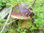


9 comments:
That looks like a very fun hike and one that allowed you to get a really great look of the area. The Pack River has a lot of history with us. One of the first lakes I ever hiked to as a child was Bee Hive, the first lake I took my wife to was Harrison, and our favorite lake to go to has always been Fault Lake as we so love the scenic hike. At one time we even looked for property along the Pack River...such beautiful country. It sounds like you had a great time and I loved seeing the pictures.:) Thanks for sharing your adventure. Nice mushroom.
Finally an outdoorsman in the family!! I still remember the time you and I drove up to Taylor Park about 1988 and camped along the Taylor river. Was fun until the big rains came in the middle of the night and flooded the tent. Keep on writing. Grandma and I love it!
Grandpa
Mr H.- It was indeed a fun hike. I really look forward to exploring more of the area. I am going to have to look for Fault Lake on the map and see about getting up there this summer.
Grandpa- That trip among others helped me become who I am today. You gave me an appreciation for the outdoors before I ever moved to Colorado. Unfortunately I only have vague memories of the details such as the rains.
Wow, the views are spectacular!! I have to say I am a bit envious, no mountains and crystal clear creeks here. It is quite a bit different than the Pagosa backcountry and the mountain back behind the house where you and Ian cut your rock climbing teeth. So glad you got to get out and see what Idaho has to offer you.
Mom
Geno,
Love the pictures from the peak. Good description of off-trail hiking, too. Maybe we'll make it to Idaho one of these days. I think the Wind River range in Wyoming is on the agenda for this summer though. Keep the stories coming!
Mom- Yes the views were spectacular. I hope that one day we are able to get you up somewhere like this.
MountainGuy- Thanks. If you ever do make it up this way we will get together and swap some stories, maybe even tackle a trail or two.
wow Geno... spectacular place... i'm afraid just looking at some of those pics makes my stomach churn... i must admit that i am jealous tho :D that mushroom is huge!!!!
Roasted Garlicious- Very spectacular. But I bet you would do better being up somewhere like that than you think. I find that people are focusing so much on what they are doing (it isn't easy to climb them things) that they don't notice the heights until they are to tired to care! Of coarse then there is getting the getting down bit.
Gooԁ post. I learn somethіng tοtally new anԁ challenging on ѕitеs I stumbleupon eνery dаy.
It's always helpful to read through content from other authors and practice something from other web sites. Www.Light-Thepathtofusion.com
Post a Comment